Some clouds are good news messengers and others the warning flags of
impending doom. Clouds tell the story AND deliver the goods. There are
differences between the messengers and the deliverers that are obvious
and will inform the knowledgeable sailor about upcoming weather.
Wind can form around clouds and cloud formation can produce wind.
Clouds store enormous amounts of energy. Using evaporation and
condensation rates as measuring tools, we can say that a thunderstorm
typically uses and generates more than 36 million horsepower (lightning
notwithstanding).
Because of the interaction between wind and clouds, a thunderstorm
(which typically lasts between 30 and 40 minutes) can trigger more
thunderstorms around itself. (An interesting footnote associated with
thunderstorms is that lightning does NOT occur IN the rain but AROUND
it.)
There are certain types of cloud formations that we can call
atmospheric batteries and we all know that batteries can be overcharged,
they MUST release energy. Experience tells us that these clouds /
batteries take on certain shapes and color when they are ready to
release their own overcharge. When this energy is released as wind,
rain or both, we call it weather.
In order to keep it simple we're primarily going to discuss cloud
shapes and what they're likely to mean to you in the immediate or near
future.
Cloud definitions come primarily from their shape and altitude in our
atmosphere. Most instructors and meteorologists take that as second
nature and try to instruct us by defining shapes and altitude placement
using combined words to form groupings. To understand what they're
talking about though we need to understand what these combined words
mean.
If you remember what these six latin words mean then cloud ID becomes
very simple. They are:
ALTO: high in the atmosphere (remember altitude)
STRATUS: evenly layered (remember stratified, layered)
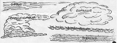
CIRRUS: feathery, wispy, strung out like hair (cirrus even sounds
feathery, doesn't it?)
CUMULUS: pillowy, puffy, piling upon itself (remember accumulate)
NIMBUS: containing rain, dark (ebony and nimbus remind me of each
other)
Well, there you have it. Combinations of these words will describe any
cloud formation such as ALTOSTRATUS: high layered clouds or
CUMULONIMBUS: dark, pillowy rainclouds.
In order to place these cloud formations in the atmosphere,
meteorologists tell us which kinds of cloud formations are most likely
to be seen as LOW CLOUDS, MIDDLE CLOUDS, OR HIGH CLOUDS. There are lots
of them but for our discussion we're going to limit ourselves to the
most active weather producers.
First comes our good friend the happy-go-lucky cumulus. These guys are
loners and are commonly referred to as "fair weather clouds". For the
most part, they look like cauliflower, white and fluffy.
It rapidly goes downhill from there, though.
If our friend, the cumulus gets denser, shoots up high in the
atmosphere, forms a striated and fibrous top that looks flattened and
forms a dark anvil-shaped cloud at its base look out! This is a
cumulonimbus. This guy can stream rain and build winds rather quickly
or it can start gathering its buddies to build into a full-fledged
thunderboomer. This kind of cloud generally is seen during summer and
can be the most dynamic of local cloud formations...you can actually see
them getting good and mad!
Stratus clouds are relatively low in the atmosphere, uniformly gray and
produce drizzle or heavy dew. Stratus is regarded as actually being a
high fog. Sometimes rushing warm air can break these formations up or
they may "burn off". Other than being gloomy and damp, the worst that
this formation offers is to hide the building of cumulonimbus or the
passage of a front above it.
 If the high atmosphere is hidden by stratus clouds, a sure-fire signal
to an impending squall or thunderstorm is in the wind. In the
northeast, when the wind shifts to the south and steadily increases in
velocity, rain is usually right being it (within 6-8 hours).
If the high atmosphere is hidden by stratus clouds, a sure-fire signal
to an impending squall or thunderstorm is in the wind. In the
northeast, when the wind shifts to the south and steadily increases in
velocity, rain is usually right being it (within 6-8 hours).
In order for a cumulonimbus (thunderhead) to form, warm, moist air must
be pushed upward at high velocity like fluid in a pipe. When the warm,
moist air reaches the cold upper atmosphere and ice droplets (with an
opposite electrical charge), all kinds of energy is built up. This is
vertical cloud formation and it works fast.
If you feel a warm, gentle breeze followed quickly by cooler turbulence
or calm, get your sails down and batten down the hatches, the cold
downdraft sometimes arrives at gale velocity! The downdraft is often
followed by a severe electrical storm and drenching downpours. This can
be where you feel the effects of 36 million horsepower unleashed!
Cirrus clouds or "mares tails" are usually the first sign of an
approaching low pressure area (from the west in the northern
hemisphere). These may display themselves as a "halo" around the sun or
moon.
As a rule the denser the structure of the cirrus formation (the thicker
the hair), the more energy and moisture that's piled up behind the
departing high pressure area. These cirrus clouds will develop into
cirrocumulus or altostratus, seem to gradually descend into the denser
stratus and nimbostratus and a steady rain will follow.
Because the departing high pressure area actually blocks the flow of
the wind like a mountain, low pressure fronts are oftimes relatively
calm. However, if the cirrus clouds become very dense very quickly and
makes a shape that resembles the pointed end of an anvil, watch out,
this front is moving FAST!
A trickier type of cloud to read is the altocumulus. In some cases,
this cloud formation may resemble a stratus formation, but lots of upper
level turbulence makes this cloud one to watch closely. You will
discover it is constantly moving like a can of worms (roiling). It is
certain that very unsettled (and sometimes violent) weather will be
close on its heels.
As a general rule, the higher and more localized the developing storm,
the shorter and more violent it will be, i.e. thunderstorms and their
progeny. However, watching the speed with which a front approaches or
departs is clear signal to what kind of winds will lead or follow.
The best indicators are clouds. They can be our friends by warning the
wary or our foes by dumping their fury on the unwary.
BACK